back

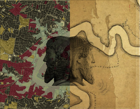
The Sedimentary City project now switches from the future Inferno City layer to uncover the earliest layers of
the past - for a recovery of origins and to set directions for mapping towards an alternative, future city.
The process for Envisioning Two is one of finding the nature of the First City, by analyzing and editing the
earliest known survey maps of the area made between 1823 – 61 to reveal, in each one, its underlying
palimpsest.
The maps represent the city at various scales and are analyzed in various, selected frames so as to understand
the wider context of the city, and the focus area as set out in ‘Envisioning One’. What we end
up with is a provisional map of the First City which is constructed from these palimpsests and supplemented by
details from the surveyors’ field books, diaries and other historical texts.
Each palimpsest is revealed, as a hidden layer, after erasing the overlaid, excess data on the surveyors’ maps.
These, and other historical data, record the underlying land and its original inhabitation, particularly its
mountains, waterways, trees and interconnecting networks of constructed pathways and monuments.
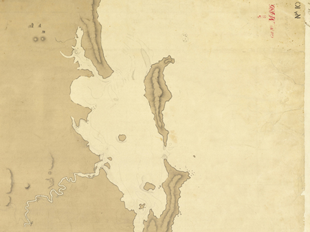
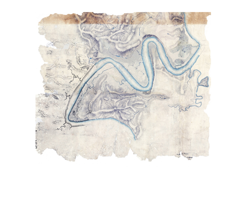
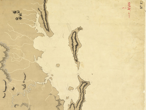
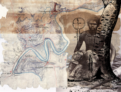
The mapping analysis begins with a survey map of the Moreton District titled ‘Skirmish Pt. to Cape Byron’.
Like most maps, its content is cumulative and its line-work is purposeful and, in this case, incorporating data from Cook and Flinders. It records the nautical measurements, the geographic features and given names of the land pertinent to ‘discovery’ – to arriving by ship and selecting a site in the Moreton Region for a new prison colony.
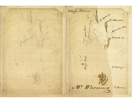
The process of mapping analysis continues by erasing Stirling’s nautical data, and excess text, from his monochrome map to reveal the palimpsest map beneath with geographical outlines of coastal areas and mountains. Records reveal that place itself was far from monotone. Stirling’s mapping of the region took place during the heat of December 1823 in a colourful, subtropical land that was home to some 5,000 inhabitants. (Hall, 1990) These inhabitants had long ago named the mountains that for these peoples were not only landmarks for way finding and lookouts but were also their monuments with long held cultural meaning. (Petrie, 1990)
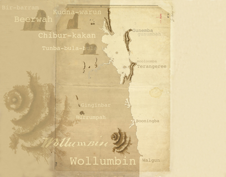
 Aboriginal place naming is often contested as these derive from different spoken languages and any meaning
ascribed to the written names is open to misinterpretation. (Dann, 1990) However, to construct a provisional
map of the First City all nautical data and all English names are scratched from Stirling’s map to uncover the
palimpsest map with its land and mountains and its restored original names. Aboriginal place naming is often contested as these derive from different spoken languages and any meaning
ascribed to the written names is open to misinterpretation. (Dann, 1990) However, to construct a provisional
map of the First City all nautical data and all English names are scratched from Stirling’s map to uncover the
palimpsest map with its land and mountains and its restored original names.
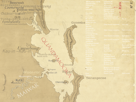
The process of detailed analysis continues with a study of the maps, field notes and other historical texts in
order to discover more of the First City, and to find, in the palimpsest, traces of its citizens’ pathways that
emerge as an extensive traffic system interlinked with the networks of ridges, waterways, vegetation and
constructed monuments.
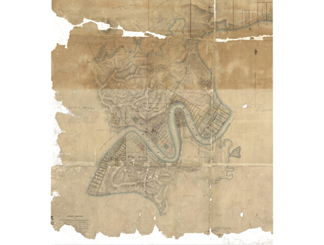
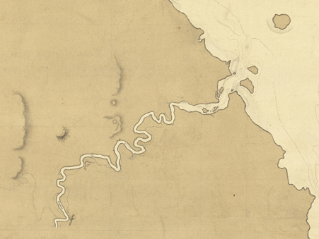
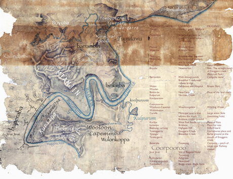
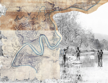
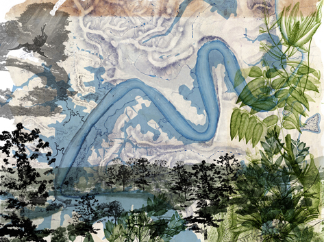
During the September 1824 expedition, to survey the Brisbane River, Oxley, Cunningham and Butler camped at the mouths of the creeks - including Breakfast Creek where they ate their morning meal and gave the place its English name. Their survey of the river draws in numerous creek outlets and the lay of the land along both sides of the riverbank. Erased of excess data, the 1823-24, survey map reveals its underlying palimpsest. With the palimpsest map and other data there emerges a picture of the wider watershed – a landscape of ridges, gullies, swamps and creeks with their outlets punctuating the riverbank in the First City. Continuing the Sedimentary City process - maps of the First City’s network of pathways are laid over maps of its watershed presenting a complex inter-relationship, between habitation and the land (mountains, ridges, gullies and plains) and the water (bay, river, creeks, swamps and lagoons). (Steele, 1984)
During Oxley’s first visit in December 1823, Lt. Stirling surveyed the river and made notes about the
characteristics of the land on both sides of the river for its potential utility and profit. The land is variously
described on the map as – ‘open, treed, hills - stony but well covered with grass, rich flats of land, gentle hills
and valleys, fine open country, rich flats, good timber, fine land, open hilly country, fine timber’ and ‘fine open
grazing country’. On his second trip Oxley, with Cunningham and Lt Butler, explored the upper reaches of the
Brisbane River from the 17th to 28th September1824 - continuing the 1823 survey from Prior’s Pocket. Oxley
and Cunningham also made a tree survey in September in1824 (Steele, 130-149). During this trip they also
made notes about trees and whilst trees along the river were regarded as magnificent, they were also eyed for
their economic value – as a valuable resource for building and for masts of ships. (Steele, 130-149)
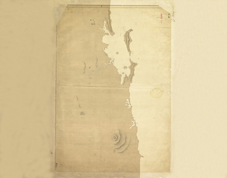
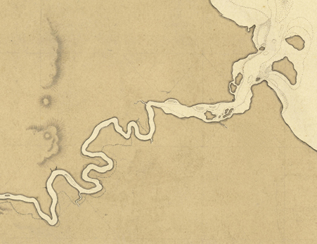
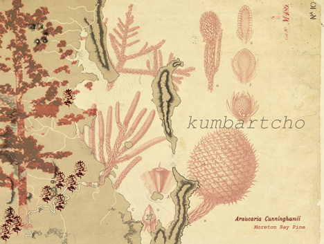
Palimpsest maps of the First City emerge after erasing excess data from survey maps by Stirlng (‘Skirmish Pt. to
Cape Byron’1823-24) and Lockyer (c.1825 ‘Brisbane River’). These maps, together with other historical data,
reveal the First City’s extensive forests on both sides of the river and along the creeks. These abundant forests
were filled with a variety of plants such as vines, staghorns and orchids and supported the world of birds,
insects and animals such as the koala, possum and kangaroo. This rich forest ecology also underpinned much of
the economic, technological, cultural and spiritual life of its citizens.

The provisional First City map is being assembled through a process of drawing-in recorded elements of its
topography – the land with its mountains, ridges, waterways and forest cover. The assemblage incorporates
the citizens’ inhabitation with place naming, marking pathways and locating major monuments constructed in
the First City such as those marking civic ceremonies and memorials to the dead.
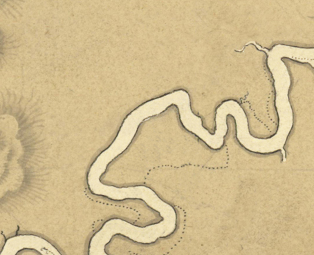
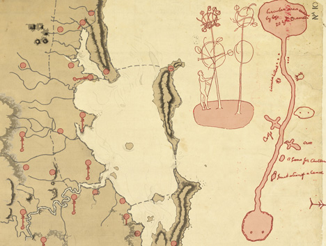
Field books for the October1824 survey of the Moreton Bay contain sketches, thought to be by surveyor
Robert Hoddle, of earth circles (a bora ground, possibly the one located at Redcliffe), comprising a large and a
small ring or circular arena connected by a wide ceremonial pathway. (Steele, In the smaller ring of the Hoddle
sketch, are shown two felled trees – mounted upside-down and decorated. There were 120 earth circle sites
estimated to have existed in the Moreton Region. (Hall, 1990)
These ceremonial tree structures and earth circles together with memorials such as the arborglyphs, which record both a death and the place of death by scaring a nearby tree truck with the tribal scars of the body of the deceased are among the many monuments constructed in the First City.
Bora grounds were typically located near sources of plentiful food and water to sustain hundreds of people attending the ceremonies for periods up to three or four weeks (Petrie 42) so that sites were often selected near the shoreline of the bay or by a river or creek. With the locations of camps and meeting grounds sited in landscapes of water and food the linking pathways throughout the region are closely interrelated with the land and waterscapes of the First City.
Envisioning Two presents us with a map of the ‘First City’– a palimpsest. Uncovering this first layer by
processes of erasure, or by peeling away layers or by selectively removing fragments from maps of later cities
and by processes of addition, by revealing lost elements through descriptions of the ‘First City’ in texts and
manuscripts, we have come to construct a provisional map of layer one.
This First City map provides a basis for reflecting spatially and temporally on creating an alternative future layer
of Sedimentary City as Envisioning Three. Reviewing the map we discover that the landscape of the First City
also floods from time to time, and that the floodplain is periodically modified in a cycle, oscillating from periods
of dry and drought to wet and flood and recreated as another landscape. In each recreation the floodplain,
along with its network of feeder creeks, provided its citizens with amenity and resources to support a rich
culture and its citizens understood how to exist in balance with this network and its cycles.
Envisioning 3 >>>
|
|
